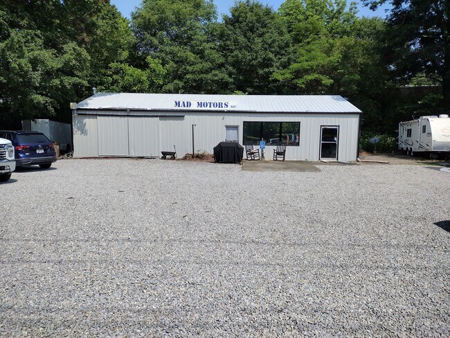
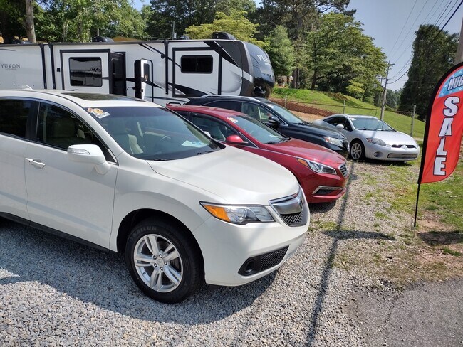
Property Record
3696 Browns Bridge Rd, Gainesville, GA 30504

NEARBY LISTINGS FOR SALE OR LEASE
Property Detail
3696 Browns Bridge Rd
Gainesville, GA
C F Waldrip
08-00039-03-035
WATSON LT 5
Commercialnec
Hall
X
Georgia
13139C0170G
5
2025
0.27 AC
2025
Gainesville/Hall Cnty
001006
Atlanta
DEMOGRAPHICS near 3696 Browns Bridge Rd
1 Mile
3 Mile
5 Mile
2024 Total Population
2,618
27,194
70,663
2029 Population
2,913
30,502
79,348
Pop Growth 2024-2029
+ 11.27%
+ 12.16%
+ 12.29%
Average Age
47
40
38
2024 Total Households
1,040
9,995
25,113
HH Growth 2024-2029
+ 11.25%
+ 12.14%
+ 12.33%
Median Household Inc
$63,923
$63,052
$64,795
Avg Household Size
2.50
2.70
2.70
2024 Avg HH Vehicles
2.00
2.00
2.00
Median Home Value
$393,455
$283,432
$292,433
Median Year Built
1988
1995
1993
Nearby Places
Map Layers
Map Styles
 Street
 Aerial
- Restaurants
- Banks
- Shops
- Fitness
- Groceries
PUBLIC TRANSPORTATION
COMMUTER RAIL
Gainesville Amtrak Station (Crescent - Amtrak)
DRIVE
WALK
Distance
Gainesville Amtrak Station (Crescent - Amtrak)
10 min
6.0 mi
Freight Ports
Georgia Ports - Savannah
DRIVE
WALK
Distance
Georgia Ports - Savannah
326 min
256.6 mi
SALE & LEASE HISTORY
LISTING DATE
SALE/LEASE

Jun 08, 2023
For Sale
Jul 11, 2023
For Lease
Nearby Properties
Address
Land Use
TOTAL SIZE
Lot Size
Zoning
Address
Land Use
TOTAL SIZE
Lot Size
Zoning
157,050 SF
144.96 AC
N-B
Address
Land Use
TOTAL SIZE
Lot Size
Zoning
92,448 SF
24.25 AC
PUD
Address
Land Use
TOTAL SIZE
Lot Size
Zoning
45,900 SF
6.99 AC
PRD
Address
Land Use
TOTAL SIZE
Lot Size
Zoning
342,720 SF
22.95 AC
PUD
Address
Land Use
TOTAL SIZE
Lot Size
Zoning
41,471 SF
27.60 AC
G-B/R-1
Address
Land Use
TOTAL SIZE
Lot Size
Zoning
1,580 SF
15.85 AC
PUD
Address
Land Use
TOTAL SIZE
Lot Size
Zoning
132,557 SF
32.85 AC
O-I
Address
Land Use
TOTAL SIZE
Lot Size
Zoning
308,672 SF
41.22 AC
L-I
Address
Land Use
TOTAL SIZE
Lot Size
Zoning
6,876 SF
10.64 AC
PRD
Address
Land Use
TOTAL SIZE
Lot Size
Zoning
1,558 SF
2.53 AC
L-I
Address
Land Use
TOTAL SIZE
Lot Size
Zoning
3,696 SF
11.89 AC
R-II
Address
Land Use
TOTAL SIZE
Lot Size
Zoning
67,718 SF
27.31 AC
PUD
Address
Land Use
TOTAL SIZE
Lot Size
Zoning
1,610 SF
6.69 AC
R-II
Address
Land Use
TOTAL SIZE
Lot Size
Zoning
68,214 SF
10.85 AC
O-I
Address
Land Use
TOTAL SIZE
Lot Size
Zoning
178,860 SF
14.72 AC
I-1
Address
Land Use
TOTAL SIZE
Lot Size
Zoning
10,050 SF
9.60 AC
C-2
Address
Land Use
TOTAL SIZE
Lot Size
Zoning
2,705 SF
8.12 AC
R-II
Address
Land Use
TOTAL SIZE
Lot Size
Zoning
42,288 SF
5.57 AC
R-B
Address
Land Use
TOTAL SIZE
Lot Size
Zoning
76,114 SF
24.54 AC
R-II
Address
Land Use
TOTAL SIZE
Lot Size
Zoning
14,848 SF
7.76 AC
PRD
Address
Land Use
TOTAL SIZE
Lot Size
Zoning
28,260 SF
19.13 AC
PUD
Address
Land Use
TOTAL SIZE
Lot Size
Zoning
72,602 SF
8.98 AC
I-1
Address
Land Use
TOTAL SIZE
Lot Size
Zoning
8,160 SF
7.46 AC
R-4
Address
Land Use
TOTAL SIZE
Lot Size
Zoning
22,000 SF
6.17 AC
C-2
Address
Land Use
TOTAL SIZE
Lot Size
Zoning
24,000 SF
11.36 AC
PCD
Address
Land Use
TOTAL SIZE
Lot Size
Zoning
72,011 SF
4.94 AC
I-1
Address
Land Use
TOTAL SIZE
Lot Size
Zoning
13.54 AC
G-B
Address
Land Use
TOTAL SIZE
Lot Size
Zoning
15,400 SF
6.05 AC
G-B
Address
Land Use
TOTAL SIZE
Lot Size
Zoning
1,600 SF
0.52 AC
V-C
Address
Land Use
TOTAL SIZE
Lot Size
Zoning
56,548 SF
9 AC
I-1
The World's #1 Commercial Real Estate Marketplace
Connect with us
© 2025 CoStar Group
The information above has been obtained from sources believed reliable. While we do not doubt its accuracy we have not verified it and make no guarantee, warranty or representation about it. It is your responsibility to independently confirm its accuracy and completeness. Any projections, opinions, assumptions, or estimates used are for example only and do not represent the current or future performance of the property. The value of this transaction to you depends on tax and other factors which should be evaluated by your tax, financial, and legal advisors. You and your advisors should conduct a careful, independent investigation of the property to determine to your satisfaction the suitability of the property for your needs.